This section doesn’t currently include any content. Add content to this section using the sidebar.

Image caption appears here

Add your deal, information or promotional text
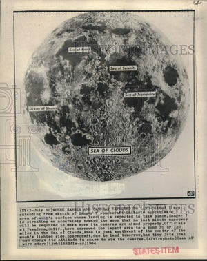
1964 Press Photo Map sketch indicates Ranger 7's moon landing area - now29031

Every photo in our collection is an original vintage print from a newspaper or news service archive, not a digital image. Please see our FAQ for more information.

Description
Dotted lines extending from sketch of Ranger 7 spacecraft indicate approximate area of moon's surface where landing is expected to take place. Ranger 7 is streaking so accurately toward the moon that no last minute maneuver will be required to make sure its cameras are aimed properly. Officials at Pasadena, California, have narrowed the impact area to a zone 30 by 120 miles in the Sea of Clouds. Area is just southwest of the center of the moon's lighted side. Spacecraft, due to land tomorrow, has tiny jets that can change its attitude in space to aim the cameras.

Photo is dated 1964.

Photo measures 8 x 10 inches.
Add To Wishlist

Search