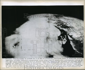
1960 Press Photo Space View of Clouds over Northeastern Portion of US & Canada
$19.99
Every photo in our collection is an original vintage print from a newspaper or news service archive, not a digital image. Please see our FAQ for more information.
Description
This un-retouched photo shows view of clouds over northeastern portion of US and Canada taken yesterday by U.S. Weather satellite, Tiros I, and released by National Aeronautics and Space Administration in Washington. NASA said picture was made at 450 miles altitude off the Atlantic coast and recorded by Army Signal Corps at Fort Monmouth, New Jersey. Dark area at lower right is Gulf of St. Lawrence. Broken line geometric pattern at left center are reference marks produced by satellite's orbital equipment.